Krepšelis tuščias
Turite Varlės paskyrą?
Prisijunkite, kad pamatytumėte krepšelio turinį
Prisijungti
Prisijunkite, kad pamatytumėte krepšelio turinį
Prisijungti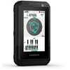
 Ši prekė
 Garmin Varia RTL515 galinis dviračio žibintas ir radaras viename
 Išmaniosios svarstyklės GARMIN Index S2 Baltos
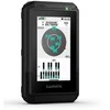
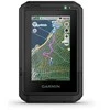
ADVENTURE IS AT YOUR FINGERTIPS
This easy-to-use handheld GPS navigation with touchscreen offers pre-loaded TopoActive maps with trails and roads for your outdoor adventures. With a durable design and long battery life, you can enjoy all your activities even more.
SCROLL AND ZOOM ON THE BRIGHT 3" TOUCHSCREEN
WITH PRE-INSTALLED MAPS FOR ROADS AND TRAILS
LONG BATTERY LIFE UP TO 130 HOURS IN GPS MODE
PLAN AND VIEW ROUTES IN THE GARMIN EXPLORE™ APP
MECHANICALLY RESISTANT DESIGN (MIL-STD 810) AND WEATHERPROOF (IP67)
SUBSCRIPTION TO PREMIUM OUTDOOR MAPS+
FEATURES YOU'LL LOVE
TOUCHSCREEN
The slim, pocket-sized handheld sat nav features a bright, high-resolution 3" colour touchscreen display where you can easily scroll and zoom through your tracked route.
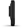
REALLY HIGH DURABILITY
The eTrex Touch navigation is specially engineered with IP67 water protection and a shockproof design (MIL-STD-810) to withstand weather and harsh conditions.
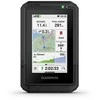
PRE-INSTALLED MAPS
View detailed TopoActive maps with roads and trails and track contours, topographic elevations, peaks, parks, rivers, lakes, geographic points of interest and thousands more. Plus, you have easy access to other TopoActive maps around the world.
OUTDOOR MAPS+
Buy a subscription to Outdoor Maps+ and get ongoing access to a wide range of premium map content, including satellite imagery, plotted campsites and more. Download and receive automatic updates via Wi-Fi®.
PLAN AND CONTROL YOUR JOURNEY
Link your device to the Garmin Explore app to plan and view your trip data on your phone or tablet. You can also manage waypoints, routes and activities in the app.
WEATHER
Get real-time weather forecasts to stay informed about changing conditions. The feature requires an active internet connection via Wi-Fi or a connection to the Garmin Explore app on a paired phone.
OUTDOOR ADVENTURES AT YOUR FINGERTIPS
IMPORTANT FEATURES
BATTERY LIFE
Get long battery life of up to 130 hours in all-satellite and multi-band mode, assuming normal use with SatIQ™ technology, and up to 650 hours in expedition mode.
GPS ACCURACY
With multi-band GPS and support for multiple GNSS networks, you'll always know where you are. Connecting to different frequencies of navigation satellites ensures excellent positioning accuracy.
DISCOVER NEW DESTINATIONS
Discover the most popular routes and rides by calculating routes by popularity. The circular route calculation allows you to enter the distance you want to travel and get recommended routes that will take you back to your starting point.
CLIMB PLANNING
On the route, you'll see upcoming climbs, when they will occur and how steep they will be.
DIGITAL COMPASS
The built-in electromagnetic digital compass allows you to determine your direction independently of the GPS signal. Compared to the GPS compass, the direction can be determined even if you are in place and not moving.
GEOCACHING
Get updates on caches you've placed from Geocaching Live, including descriptions, logs and hints. If you're connected to the Garmin Explore app on a compatible phone, every cache you find will automatically load to your geocaching.com profile.
GARMIN SHARE
You can easily share saved routes and location data with compatible Garmin friends' devices.
MOUNTING OPTIONS
The navigation has an integrated Spine Mount 2 mounting system and is compatible with optional accessories sold separately.


")
")


")
")


